- Denby Jorgensen
- View Portfolio
- Image 1 of 7
- Added 30 Sep 2006
- 167 Views
- 1 Comment
- 1 Favorite
- Share This Image On...
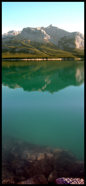
The north face, as seen from Windy Point on Abraham Lake. Just off of the David Thompson Highway #11. Taken Sept. 3, 2006 52°15'10.64"N 116°23'33.92"W Mount Michener, with a 2,545 metre peak, is a mountain on the eastern border of the Canadian Rockies forming the northerly part of the Ram Range. It sits on the shore of Abraham Lake and its north, west and south face are all visible from the David Thompson Highway. The mountain was named in 1982 after Daniel Roland Michener who was the Governor General of Canada from 1967 - 1974. Its previous names were Eye Opener Mountain and Pheobe's Teat, reportedly after a woman from Rocky Mountain House who would periodically visit the Nordegg miners in the 1930s. (wikipedia) DJorgensen © 2006
1 Comment
Emilio B. Campo-Diaz 01 Oct 2006
Excellent photo, I like it.